Redefining Road Asset Management for the Next Generation of Infrastructure
Our AI-powered platform transforms how organisations capture, assess, and maintain road networks, unlocking new levels of efficiency, safety, and cost control.
Analytics
Performance in Numbers
See what Roadern delivers in action, from network coverage to AI-powered precision and speed.
0
mi
Roads Surveyed
0
Defects Detected
0
min/mi
Instant Results
0
%
Accuracy Delivered
Introducing Roadern
Engineered for the Future
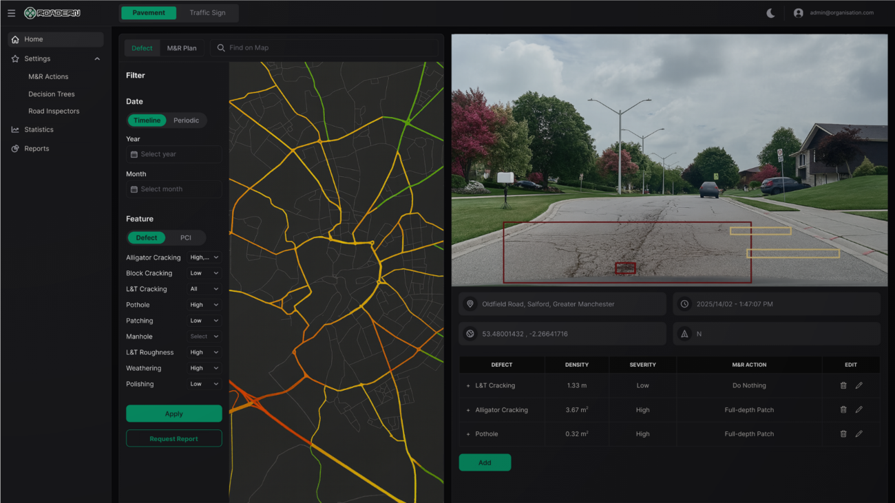
Pavement
Pavement
Fast, Accurate, and Standards-Compliant
Roadern enables rapid pavement condition assessments using just a smartphone. Field teams capture road images through our mobile app, and our AI models instantly process them to detect defects, classify severity, and measure dimensions, all in accordance with ASTM D6433 standards. Within minutes, users receive a full Pavement Condition Index (PCI) and detailed analysis via our cloud dashboard. Access, review, and export high-resolution results in both Excel and shapefile formats, ready for action, planning, or reporting.
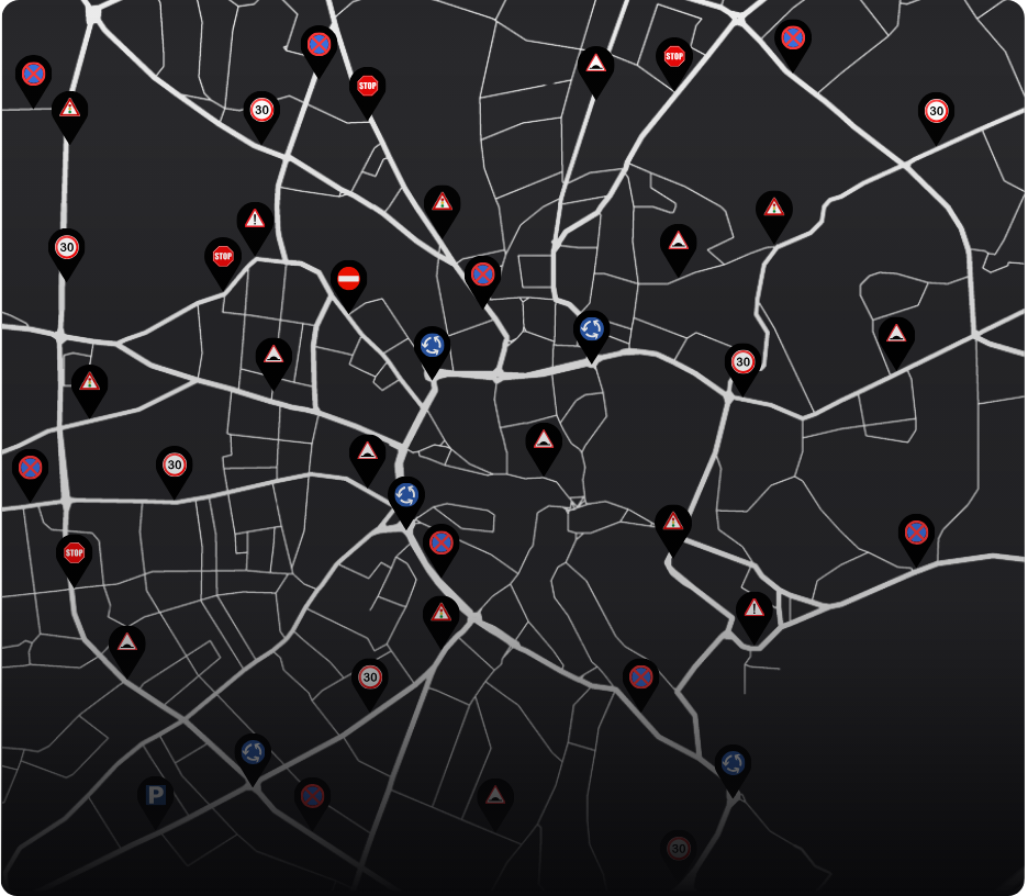
Signs
Coming Soon
Signs
Coming SoonVisibility and Compliance at a Glance
Roadern empowers teams to evaluate traffic signs with speed and precision. Using our mobile app, users capture roadway imagery that is instantly analysed by our AI models to detect sign types, assess their condition, and flag issues. Within minutes, results are available via our secure dashboard, with full export options in Excel and shapefile formats for seamless integration into planning workflows.
Markings
Coming Soon
Markings
Coming SoonReal-Time Analysis for Safer Roads
Roadern enables accurate evaluation of road markings through effortless mobile image capture and real-time AI analysis. Our models detect and classify markings, assess their visibility and condition, and identify areas requiring maintenance, all with no human input. Processed data is available within minutes via our interactive dashboard, ready to view or export in Excel and shapefile formats.
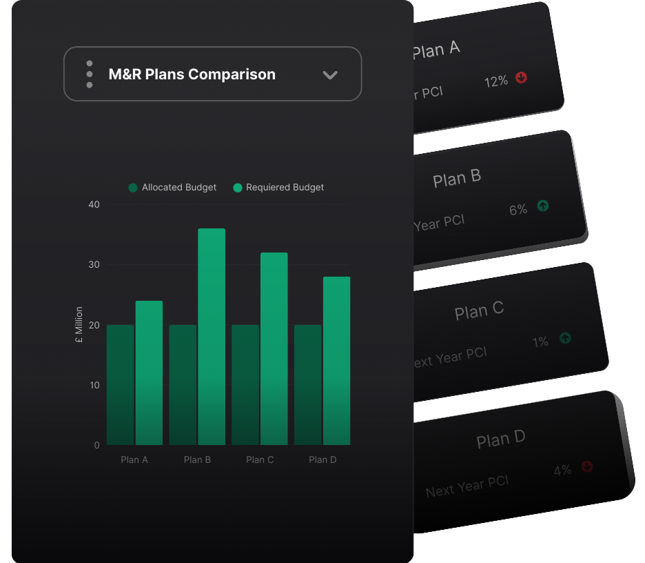
Planning
Planning
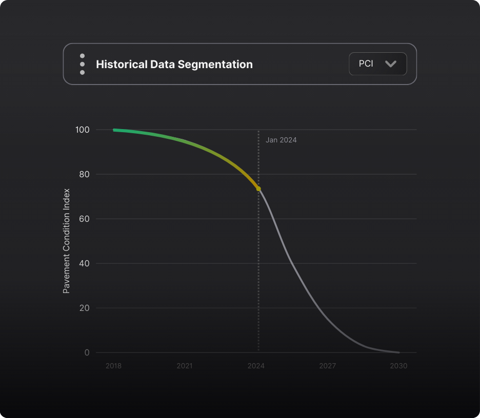
Smart Strategies Aligned with Real-World Constraints
Roadern transforms raw condition data into actionable maintenance and rehabilitation plans across pavement, signage, and road markings. Our AI models prioritise interventions based on factors such as risk, then optimise plans to fit real-world constraints like budget. All planning outputs are available via our dashboard within minutes of analysis, and can be easily exported in Excel and shapefile formats for integration into any asset management system.
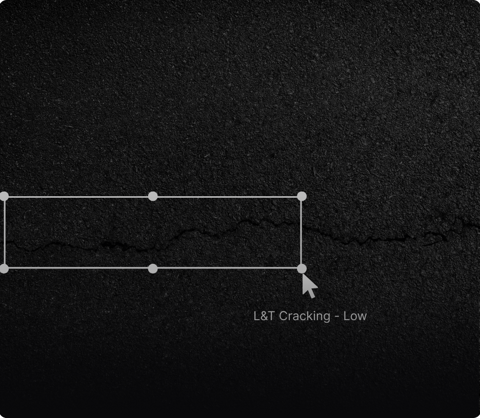
Editing
Editing
Built-In Flexibility and Control
Every dataset generated by Roadern undergoes a quality check by our transportation engineering team to ensure reliability. In addition, users can seamlessly review and refine AI-generated outputs through our intuitive, interactive editing tools within the data dashboard. This added layer of oversight empowers teams to maintain full confidence in the data they use and the decisions they make.
Customising
Customising
Engineered for Strategic Alignment
Roadern adapts to the organisation’s unique operational resources by allowing full customisation of maintenance and rehabilitation strategies. Users can define their own actions, set associated costs, and configure decision trees that reflect local standards or engineering policies. These custom inputs are seamlessly integrated into our planning engine, ensuring that every recommendation aligns with the user’s specific context. Updated outputs are instantly accessible via the dashboard and available for download in Excel and shapefile formats.

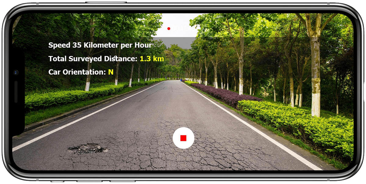
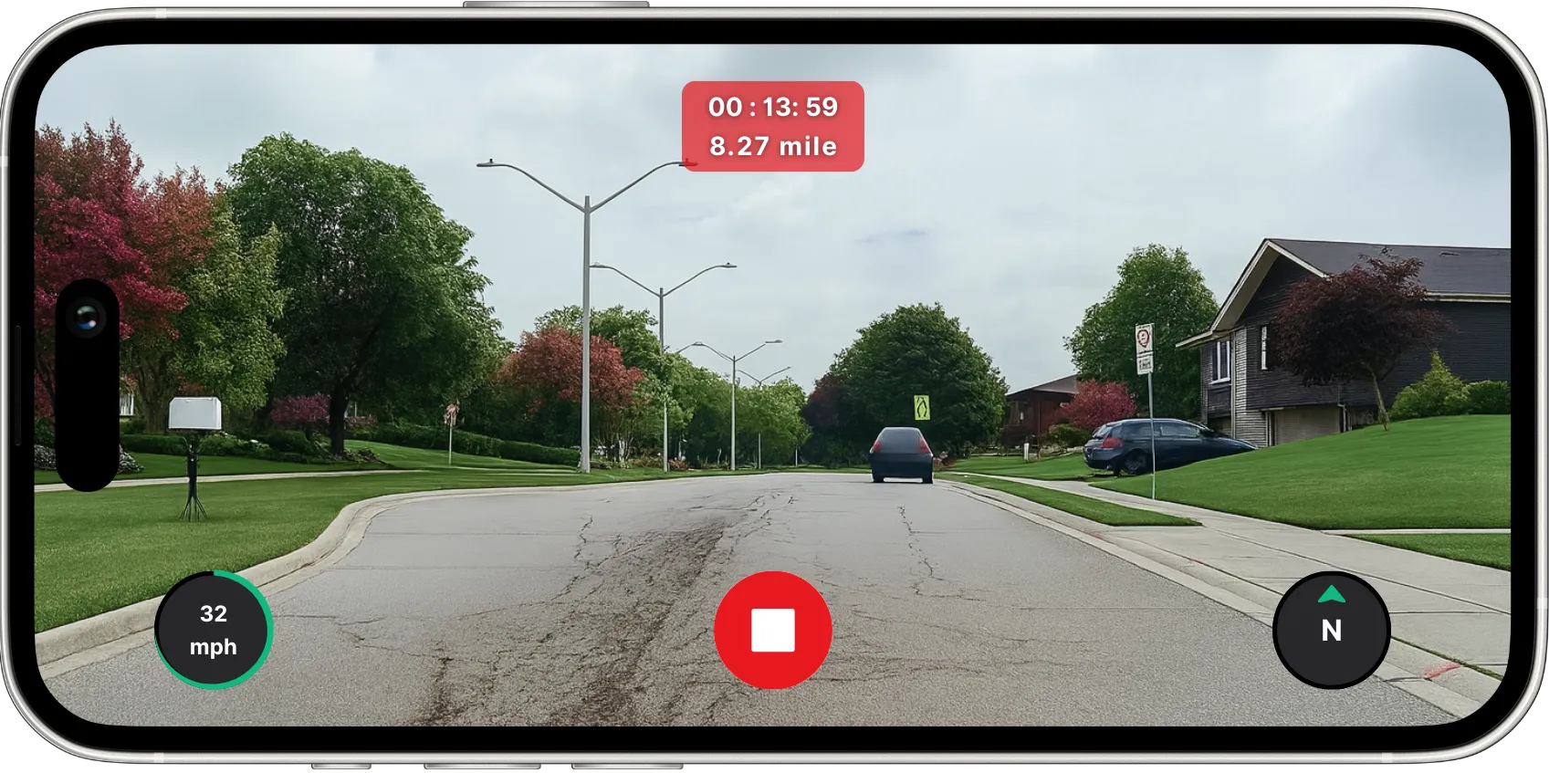
Assessment
Smart Inspections, Zero Complexity
Capture road condition data using just a smartphone. Roadern’s AI analyses images in minutes. No sensors, no special hardware, no technical expertise needed.
Assessment
Smart Inspections, Zero Complexity
Capture road condition data using just a smartphone. Roadern’s AI analyses images in minutes. No sensors, no special hardware, no technical expertise needed.

Strategy
AI-Powered Planning, Ready to Deploy
Our models turn field data into fully optimised maintenance plans, tailored to your standards, priorities, and constraints.
Strategy
AI-Powered Planning, Ready to Deploy
Our models turn field data into fully optimised maintenance plans, tailored to your standards, priorities, and constraints.

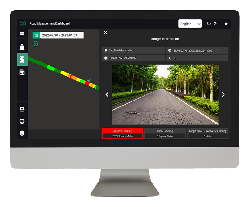
Oversight
Accurate, Customised, and Exportable
Access high-resolution results through our dashboard. Review, edit, and export everything, from PCI scores to maintenance plans, with full control and confidence.
Oversight
Accurate, Customised, and Exportable
Access high-resolution results through our dashboard. Review, edit, and export everything, from PCI scores to maintenance plans, with full control and confidence.
Advantages
Built With Purpose. Trusted for Performance.
Discover the core advantages that make Roadern a modern standard for road asset management.

Comprehensive Platform
Designed to support every stage of the process, from field surveys to long-term strategies, all within one unified system.

Real-Time Intelligence
Get instant access to AI-processed data. Our platform delivers results within minutes, enabling on-time decision and responsive action.

Standards-Compliant Output
Every result is aligned with industry standards, ensuring technical reliability and seamless integration into public workflows.
FAQs
Your Questions, Answered
We have covered the essentials to help you get started with confidence.
Roadern eliminates the safety risks of on-foot surveys while significantly reducing costs and turnaround time. With automated data collection and AI-powered analysis, results are fast, consistent, and free from subjective interpretation.
Unlike expensive data collection vehicles, Roadern requires no specialised hardware, just a smartphone. Our AI models process images in under 300 milliseconds, enabling fast, scalable, and continuous network monitoring.
Yes. Our validation tests confirm that Roadern’s outputs match the accuracy of vehicle-based systems, powered by advanced AI models and a robust quality assurance process.
Roadern’s cost-efficiency allows authorities to monitor entire networks more frequently, leading to smarter investments, reduced long-term maintenance costs, and improved road user satisfaction.
Contact Us
Get in Touch
Reach out to learn more about Roadern, schedule a demo, or explore how we can support your asset management needs.
United Kingdom